Satellite imagery can also be used, for example, to track the condition of forests by monitoring changes in tree cover, to identify illegal logging or land use practices that may damage ecosystems, and to monitor the flow of pollutants and other substances through the environment.
Catastrophe on the Oder river – could we have foreseen it?
This year’s ecological disaster in the Oder river was, according to Polish and German reports, most likely the result of rapid growth of the algae species Prymnesium parvum, the so-called ‘golden alga’. According to scientists, the massive bloom could have been triggered by various factors, including heat, hydrological drought, high sunlight or chemical pollution. Similar situations may also occur in the future, but ongoing analysis of satellite imagery, correlated with sensors placed in the water, can help to predict them and, in time, trigger preventive measures.
In fact, algae are found in almost all bodies of water, both marine and freshwater. Photosynthesising phytoplankton, although not usually a serious threat, fills an important niche at the bottom of the food chain providing nutrition for many species. The problem arises when algal blooms occur suddenly and abruptly and include species that can quickly destabilise and destroy surrounding ecosystems. Such a situation has been encountered in the Oder River, but the problem also affects other watercourses and reservoirs, including coastal water belts, basically all over the world. Rapid algal growth has a negative impact not only on the organisms living in the water but also on the entire economic sectors – such as water transport and tourism.
Algae visible from space
Interestingly, the rapid algal bloom is perfectly visible on satellite images. In fact, they are already being used to monitor such phenomena in other countries.
“When we analyse the satellite images, determining the NDCI chlorophyll content index from them, we can see a moment of intense algal growth. Already at a glance, we can see that the chlorophyll content index in the Oder River in July was much lower than in August. We do not observe a similar phenomenon in the nearby Stawskie Lake.” – says Artur Nowakowski, PhD, an expert in the study of satellite imagery from TUATARA, who is in charge of, among other things, analysing images using artificial intelligence.
It is worth mentioning that Artur Nowakowski, PhD, analysed publicly available images from the Sentinel-2 satellite. In the case of commercial data applications, it is possible to obtain much better images, with greater resolution and detail, and – above all – coming from much closer temporal locations. Appropriate collation and analysis of such images can allow the exact moment of threat to be detected.
“It is quite easy to imagine a permanent analysis of this type of imagery using satellite image analysis techniques and artificial intelligence so that disturbing phenomena are detected and reported almost immediately, or it is even possible to estimate their risk sometime in advance. Combined with a system of sensors or river surveys, which representatives of public institutions talk about, this could provide an excellent early warning system so that the relevant services can react in time in similar cases in the future.” – Nowakowski, PhD, adds.
Satellite data have great potential to contribute to the further elucidation of the Oder catastrophe. However, it is worth remembering that, regardless of the true causes of the disaster, the analysis of satellite images is a tool that can help, above all, in the ongoing welfare of Poland’s reservoirs and waterways. It is already possible to use them, for example, to trace illegal sources of pollution (such as chemical discharges as discussed in the context of the Oder River), monitor water levels or chemical spills.
It is quite easy to imagine a permanent analysis of this type of imagery using satellite image analysis techniques and artificial intelligence so that disturbing phenomena are detected and reported almost immediately, or it is even possible to estimate their risk some time in advance. Combined with a system of sensors or river surveys, which representatives of public institutions talk about, this could provide an excellent early warning system so that the relevant services can react in time in similar cases in the future. Artur Nowakowski, PhD
EARTH OBSERVATIONS LEAD AT TUATARA
Satellite images at the service of the environment
Analysis of satellite imagery can help protect the environment, not just watercourses and reservoirs. It can be used effectively to monitor natural systems and identify potential threats. For example, satellite imagery may be utilized in tracking the condition of forests by monitoring changes in tree cover, identifying illegal logging or land use practices that may damage ecosystems, and monitoring the flow of pollutants and other substances through the environment. It also applies to the monitoring of possible natural disasters such as fires, floods, and hurricanes, providing vital information to assist in disaster response and recovery.
One of the key benefits of satellite imagery analysis in environmental protection is the ability to collect and analyse large amounts of data on a regular basis, allowing for continuous monitoring and assessment of the environment. For example, through satellite imagery, we can have a better view of the movement of pollutants and other harmful substances, and easier identify potential sources of contamination as well as take actions that would prevent further damage. 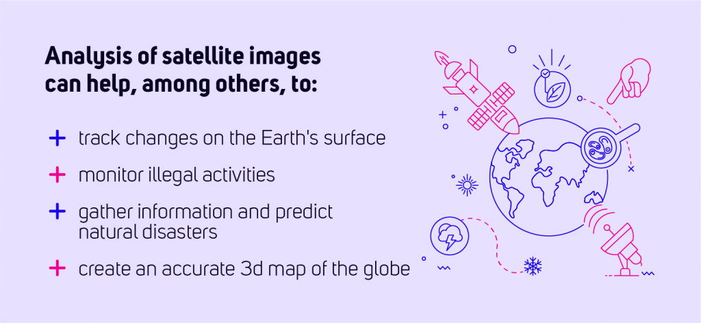
Another great example of satellite imagery analysis application is the ongoing verification of forests, wetlands and other natural habitats’ health, enabling early detection of changes that could affect the well-being of those ecosystems. Analysis of satellite imagery is a powerful tool for protecting the environment and ensuring the health of natural systems for future generations.
Through satellite data analysis, we can:
- Identify and monitor changes in the Earth’s surface, including vegetation cover and land use changes, to track the state of natural systems.
- Detection and monitoring of illegal activities, such as logging or mining, which can harm the environment.
- Monitoring the flow of pollutants and other substances through the environment.
- Provide detailed and accurate information on natural disasters such as fires, floods and hurricanes to assist in response and recovery.
- Creation of detailed maps and 3D models of the Earth’s surface that can be used in various environmental applications.
- Monitoring and enforcement of compliance with environmental legislation.
- Regular collection of large amounts of data to enable continuous monitoring and assessment of the environment.